Interestingly there was a lack of adoption of many common open source geospatial tools. Turns out that open source is competing in the market with "free as in beer" products. I imagine that will shape into quite the dust up in the years ahead.
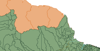
The other surprise for me was that GeoServer could not really be used; turns out that the local coordinate reference system for the Brazilian datasets was in a projection not supported by GeoTools. I managed a little bit of research into the topic; collecting some data samples and so on.
Over the holidays Andrea managed to implement the missing "Polyconic Projection" and it is great to have visual confirmation of the result.

Thanks for this fix Andrea - it really will open up a new market for GeoTools.