GeoTools

OSGeo

Tuesday, January 21, 2014

GeoTools 11-beta released

The GeoTools community overjoyed to bring you the latest GeoTools 11-beta download:
As an alternative to downloading this release has been deployed to our maven repository.

This release is made in conjunction with GeoServer 2.5-beta, please see the GeoTools 11-beta Release Notes for additional details.

We encourage all projects that make use of GeoTools to update and evaluate GeoTools-11-beta. This is your best opportunity review incoming changes / integration issues before the project enters the release candidate status, next month.

About GeoTools 11.x Series

Summary of the new features for the GeoTools 11.x series:

  • The DataStore API has a new removeSchema method to drop feature types. This new optional feature is currently implemented by the JDBCDataStore family (all spatial database backed stores), other stores will likely throw an UnsupportedOperationException
  • JDBCDataStore now exposes facilities to list, create and destroy indexes on database columns.
  • Ability to create and drop databases from the PostgisNGFactory
  • PostGis data store will now call ST_Simplify when the GEOMETRY_SIMPLIFICATION hint is provided, significantly speeding up loading of complex geometries  (the renderer can perform scale based simplification already, but doing it before sending the data speeds up data retrieval significantly)
  • ImageMosaic can now manage vector footprints for its granules, allowing to filter out no-data or corrupted sections of the imagery
  • All properties in a SLD style can now have a local unit of measure, as opposed to specifying the unit of measure per symbolizer. For example, if you need to have a line width to be 10 meters, its value can now be "10m"
  • Improved handling of data with 3D coordinates in JDBC data stores
  • A number of small improvements to the rendering engine, such as improved raster icon placement resulting in cleaner, less blurry output, improved label grouping, better handling of icons at the border of the map and in general much improved estimation of the buffer area needed to include all symbols in a map (for features that sit outside the map, but whose symbols are big enough to enter it).

Monday, January 20, 2014

GeoTools 10.4 Released


The GeoTools community is happy to bring you the latest GeoTools 10.4 download:
This release is available from our Maven repository for use with your build system.

Only a few fixes this month:
  • Assorted Image Mosaic improvments
  • A few Symbology Encoding parsing fixes
  • SQL Server distance filter encoding bug
  • Please see the GeoTools 10.4 Release Notes for additional details
This release is made in conjunction with GeoServer 2.4.4.

About GeoTools 10.x Series

Summary of the new features for the GeoTools 10.x series:
  • Structured grid coverage readers allow raster data sources that publish composite data products to expose individual rasters (ie granules) for processing, while still providing a seamless experience for rendering. The mosaic and NetCDF modules are the first ones to implement these new interfaces.
  • Efficient support for multiple coverages in GridCoverageReader provides ad-hoc access to raster formats that publish more that one data product. A image mosaic made of NetCDF granules and single file NetCDF sources are the first implementors of these new capabilities
  • new implementation of Shapefile DataStore (based on ContentDataStore superclass). This upgrade should be seamless for all users using DataStoreFactoryFinder. If you explicitly made use of the ShapefileDataStore or IndexedShapefileDataStore class please check the upgrade instructions.
  • The transform module graduated to supported status, providing a seamless way to rename, retype and hide SimpleFeatureSource attributes, as well as creating new ones based on OGC Expression
  • Additional OGC modules for the WCS 2.0 and WCS 2.0 EO models as well as adding XML parsers and encoders
  • Support for fills made with randomized symbols
The 10.x series features a number of research and development activities:
  • NetCDF has been updated to take advantage of the new coverage API introduced above
  • GeoPackage: a sample implementation of the geopackage spec that is currently being developed by the OGC
If you are interested in helping out please introduce yourself on geotools-devel mailing list.

Enjoy,
The GeoTools Community
http://geotools.org

Tuesday, December 17, 2013

GeoTools 10.3 Released

The GeoTools community is happy to bring you the latest GeoTools 10.3 download:
This release is available from our Maven repository for use with your build system.

Only a few fixes this month:
  • Assorted rendering fixes for symbols rendered at a maps edge
  • Fixes for dash-stroke line offset
  • Please see the GeoTools 10.3 Release Notes for additional details.
This release is made in conjunction with GeoServer 2.4.3.

About GeoTools 10.x Series

Summary of the new features for the GeoTools 10.x series:
  • Structured grid coverage readers allow raster data sources that publish composite data products to expose individual rasters (ie granules) for processing, while still providing a seamless experience for rendering. The mosaic and NetCDF modules are the first ones to implement these new interfaces.
  • Efficient support for multiple coverages in GridCoverageReader provides ad-hoc access to raster formats that publish more that one data product. A image mosaic made of NetCDF granules and single file NetCDF sources are the first implementors of these new capabilities
  • new implementation of Shapefile DataStore (based on ContentDataStore superclass). This upgrade should be seamless for all users using DataStoreFactoryFinder. If you explicitly made use of the ShapefileDataStore or IndexedShapefileDataStore class please check the upgrade instructions.
  • The transform module graduated to supported status, providing a seamless way to rename, retype and hide SimpleFeatureSource attributes, as well as creating new ones based on OGC Expression
  • Additional OGC modules for the WCS 2.0 and WCS 2.0 EO models as well as adding XML parsers and encoders
  • Support for fills made with randomized symbols
The 10.x series features a number of research and development activities:
  • NetCDF has been updated to take advantage of the new coverage API introduced above
  • GeoPackage: a sample implementation of the geopackage spec that is currently being developed by the OGC
If you are interested in helping out please introduce yourself on geotools-devel mailing list.

Enjoy,
The GeoTools Community
http://geotools.org

Tuesday, November 19, 2013

GeoTools 10.2 released

The GeoTools community is happy to bring you the latest GeoTools 10.2 download:
As an alternative to downloading this release has been deployed to our Maven repository.

This release is made in conjunction with GeoServer 2.4.2 and GeoWebCache 1.5.0.

Notable in this release:

  • Fixes in Oracle for mixed geometry collections and SQL Server to handle geometries with Z
  • Minor rendering fixes for dashed lines over tiled displays
  • GML3 fixes for parsing data with 3D ordinates
  • New support for fills made with randomized symbols has been backported to the stable series


Please see the GeoTools 10.2 Release Notes for additional details.

About GeoTools 10.x Series

Summary of the new features for the GeoTools 10.x series:
  • Structured grid coverage readers allow raster data sources that publish composite data products to expose individual rasters (ie granules) for processing, while still providing a seamless experience for rendering. The mosaic and NetCDF modules are the first ones to implement these new interfaces.
  • Efficient support for multiple coverages in GridCoverageReader provides ad-hoc access to raster formats that publish more that one data product. A image mosaic made of NetCDF granules and single file NetCDF sources are the first implementors of these new capabilities
  • new implementation of Shapefile DataStore (based on ContentDataStore superclass). This upgrade should be seamless for all users using DataStoreFactoryFinder. If you explicitly made use of the ShapefileDataStore or IndexedShapefileDataStore class please check the upgrade instructions.
  • The transform module graduated to supported status, providing a seamless way to rename, retype and hide SimpleFeatureSource attributes, as well as creating new ones based on OGC Expression
  • Additional OGC modules for the WCS 2.0 and WCS 2.0 EO models as well as adding XML parsers and encoders
The 10.x series has a number of research and development activities that may be of interest:
  • NetCDF has been updated to take advantage of the new coverage API introduced above
  • GeoPackage: a sample implementation of the geopackage spec that is currently being developed by the OGC
While exciting, this functionally is looking for volunteers and/or funding to meet our quality assurance standards. If you are interested please introduce yourself on geotools-devel (or check out options for commercial support).

Enjoy,
The GeoTools Community
http://geotools.org

Monday, October 21, 2013

GeoTools 10.1 Released

The GeoTools community is happy to bring you the latest GeoTools 10.1 download:
As an alternative to downloading this release has been deployed to our Maven repository.

This release is made in conjunction with GeoServer 2.4.1 and GeoWebCache 1.5.0.

Please see the GeoTools 10.1 Release Notes for additional details.

About GeoTools 10.x Series

Summary of the new features for the GeoTools 10.x series:
  • Structured grid coverage readers allow raster data sources that publish composite data products to expose individual rasters (ie granules) for processing, while still providing a seamless experience for rendering. The mosaic and NetCDF modules are the first ones to implement these new interfaces.
  • Efficient support for multiple coverages in GridCoverageReader provides ad-hoc access to raster formats that publish more that one data product. A image mosaic made of NetCDF granules and single file NetCDF sources are the first implementors of these new capabilities
  • new implementation of Shapefile DataStore (based on ContentDataStore superclass). This upgrade should be seamless for all users using DataStoreFactoryFinder. If you explicitly made use of the ShapefileDataStore or IndexedShapefileDataStore class please check the upgrade instructions.
  • The transform module graduated to supported status, providing a seamless way to rename, retype and hide SimpleFeatureSource attributes, as well as creating new ones based on OGC Expression
  • Additional OGC modules for the WCS 2.0 and WCS 2.0 EO models as well as adding XML parsers and encoders
The 10.x series has a number of research and development activities that may be of interest:
  • NetCDF has been updated to take advantage of the new coverage API introduced above
  • GeoPackage: a sample implementation of the geopackage spec that is currently being developed by the OGC
While exciting, this functionally is looking for volunteers and/or funding to meet our quality assurance standards. If you are interested please introduce yourself on geotools-devel (or check out options for commercial support).

Enjoy,
The GeoTools Community
http://geotools.org

Friday, October 4, 2013

Randomized Fill

Quick cool new feature thanks to the always impressive @geowolf. Andrea is a man of few words and many examples so let me turn you over to his email.
Hi, 
The randomized fill support discussed some time ago has landed on trunk. 
Cheers 
Andrea 
PS: A note about the params and their default value:
  • random: false
  • random-seed: 0 (the seed for the random generator, change its value to get a different distribution at the same density)
  • random-symbol-count: 16
  • random-tile-size: 256 (the size of the tile... this default is large for small symbols... but ok for larger pictures...)
  • random-space-around: 0 (conflict resolution control, similar to labels, < 0 allows for overlap, > 0 pushes symbols further apart)
  • random-rotation: false (whether to randomly rotate the symbols as well, or not)
  • random-grid: true (if true the symbols are randomized around the centers of a regular grid, when false it's really fully random)
PPS: I'd wish to port it back to the stable series next month if nothing breaks
Thanks to New South Wales Geological Survey for sponsoring this work.

(Check out the original email for the XML code examples, click on the images for larger size).

Randomized Slash Symbols

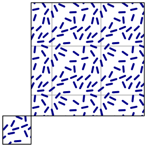
Here is one with randomized "slash" symbols, with a background box fill that helps visualize the "unit" of the random fill, the image that is getting repeated over and over:
In this case the randomization is grid based, that is, symbols are not actually
spread out fully randomly, each of them is actually placed at a controlled random 
distance from the centers of an invisible grid. Random, but not completely so.

Fully Random without Rotation

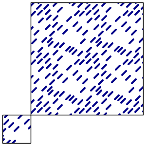
Here is one fully random, and without random rotation. As you can see, there are some holes
in the pattern that the gridded version did not have.


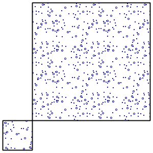
Fully Random


Here is a fully random one, actually, two, superimposed (see how the seed got changed to avoid getting
the same point distribution twice in a row, which would have made the larger circles just cover the small ones).


Theme Example


As a closing example, the usual topp:states depicted using varying dot density:


Friday, September 20, 2013

GeoTools 10.0 Released

The GeoTools community is happy to bring you the latest GeoTools 10.0 download:
As an alternative to downloading this release has been deployed to our maven repository.

This release is made in conjunction with GeoServer 2.4.0 and GeoWebCache 1.5.0. We would to thank everyone who has helped out with testing.

Please see the GeoTools 10.0 Release Notes for additional details.

About GeoTools 10.x Series

Summary of the new features for the GeoTools 10.x series:
  • Structured grid coverage readers allow raster data sources that publish composite data products to expose individual rasters (ie granules) for processing, while still providing a seamless experience for rendering. The mosaic and NetCDF modules are the first ones to implement these new interfaces.
  • Efficient support for multiple coverages in GridCoverageReader provides ad-hoc access to raster formats that publish more that one data product. A image mosaic made of NetCDF granules and single file NetCDF sources are the first implementors of these new capabilities
  • new implementation of Shapefile DataStore (based on ContentDataStore superclass). This upgrade should be seamless for all users using DataStoreFactoryFinder. If you explicitly made use of the ShapefileDataStore or IndexedShapefileDataStore class please check the upgrade instructions.
  • The transform module graduated to supported status, providing a seamless way to rename, retype and hide SimpleFeatureSource attributes, as well as creating new ones based on OGC Expression
  • Additional OGC modules for the WCS 2.0 and WCS 2.0 EO models as well as adding XML parsers and encoders
The 10.x series has a number of research and development activities that may be of interest:
  • NetCDF has been updated to take advantage of the new coverage API introduced above
  • GeoPackage: a sample implementation of the geopackage spec that is currently being developed by the OGC
While exciting, this functionally is looking for volunteers and/or funding to meet our quality assurance standards. If you are interested please introduce yourself on geotools-devel (or check out options for commercial support).

Enjoy,
The GeoTools Community
http://geotools.org