GeoTools

OSGeo

Friday, March 26, 2010

GeoTools 2.6.3 released

The GeoTools project is pleased to announce the release of GeoTools version 2.6.3.

This release is a bug fix release (27 issues fixed) made in conjunction with uDig 1.2-RC2. A special thank you to to community members that submitted patches this release.

Improvements and new capabilities:
  • Improvements to JMapPane thanks to an active user list
  • Support for WMS Extent and Dimension information
  • Support for the Robinson projection
We also have a few internal improvements:
  • Support for Online Test cases using JUnit4
For the complete list please review the 2.6.3 release notes.

GeoTools 2.6.3 is available from source forge:

Or from our public maven or subversion repositories:

The GeoTools Community

Thursday, March 4, 2010

GeoTools 2.6.2 released

The GeoTools project is pleased to announce the release of GeoTools version 2.6.2.

This release is mostly intended to provide a number of important bug-fixes, but there are also some new features and improvements for your programming pleasure including:
  • The rendering system now has the ability to draw polygon fills and SVGs as vectors and draw marks with arbitrary sizes.
  • GeoTools applications can now use the H2 database with a spatial index provided by Hatbox.
  • Support added for polyconic projections.
Refer to the 2.6.2 release notes for full details.

You can download the complete GeoTools 2.6.2 source distribution from Sourceforge, or click the 'View all files' button on that page for separate downloads for pre-compiled binaries and javadocs. You can also download the source code with your favourite Subversion client from: http://svn.osgeo.org/geotools/tags/2.6.2

If you use Maven as your build tool, simply update the version number for GeoTools modules in your pom.xml files to "2.6.2".

Share and enjoy !
The GeoTools Community

Tuesday, March 2, 2010

Make your own map-based mashup

IBM produced a nice tutorial making use of GeoTools, JTS and SkateKML with the ever present OpenLayers and PostGIS database.

The tutorial mostly uses the MathTransform services to handle coordinates. You can actually use GeoTools DataStore to perform the SQL query for you resulting in a FeatureCollection. The IBM tutorial performs these steps by hand (Constructing the SQL and translating Well Known Binary into a JTS Geometry etc...).

For more information on using GeoTools FeatureCollection please review QueryLab (java).

Wednesday, February 24, 2010

GeoTools continuous map wrapping

Recently the GeoTools team under GeoSolutions' funding has addressed an issue with the rendering module that was preventing users from drawing polygons crossing the dateline change, or, to put it another way, to be able to have maps that were wrapping like continuous wrapped maps from Google.


As an example specific use case involved the use of a projection in which the dateline change has been moved away from the usual -180/+180 by using a non standard central meridian
The result, prior to the work described here, does not look so good across the discontinuity, as shown below


Bad results when crossing the dateline


The problem was that our renderer was performing point by point reprojections, therefore when a point was crossing the dateline the modular math we used kicked in, transforming +181 -> -179. This meant that the next point, when crossing the dateline, was moved to the other side of the world.


In order to perform proper processing of projection singularities and dateline wrapping on selected projections, in particular, Mercator, Transverse Mercator, and flat geographic, we have had to modify the renderer in its projection handling part. The outcome is that we finally have obtained seamless wrapping maps similar to the Google ones, as shown here:
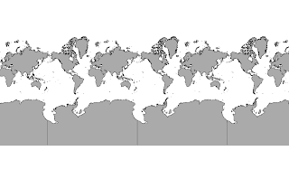

Continents Oracle layer with EPSG:3329
Continents layer from Oracle datastore in EPSG:3329


Continents Oracle layer with EPSG:90013
Continents layer from Oracle datastore in EPSG:90013


You can try this work yourself starting from GeoTools 2.5.x and above. On the development versions of the two software the tweak is automatically applied while on the other side for the stable versions you need to specify two JVM options:
-DADVANCED_PROJECTION_ HANDLING=true
-DUSE_STREAMING_RENDERER=true

A big thanks goes to Andrea Aime who has been hired for the implementation of this feature.

Thursday, January 14, 2010

GeoTools 2.6.1 Released

The GeoTools 2.6.1 release is now available for download:
This release contains a host of improvements and bug fixes. In particular the JMapPane has received a lively round of testing and feedback, MySql is back among the supported data stores in its JDBC-NG implementation along with MS SQL Server and SpatiaLite.

The epsg-hsql module now creates its cached EPSG database much faster and with better concurrency control, and a new projection, the polyconic one, has been added to the referencing subsystem.

The rendering subsystem can now accept Function as a source for the Symbolizer geometry, meaning it's possible to perform a transformation (buffer, offset, point extraction) before the actual rendering chain starts (transformations are applied in the geometry native coordinate reference system).Also new is the ability to automatically displace point and polygon labels in search for a position that is not used by another label, using the same vendor parameter already available for lines.

A brand new JPEG2000 coverage reader that can leverage on kakadu has been added, more information can be found here.

Sunday, January 10, 2010

Polyconic

A couple of things surprised me in a recent trip to Brazil.

Interestingly there was a lack of adoption of many common open source geospatial tools. Turns out that open source is competing in the market with "free as in beer" products. I imagine that will shape into quite the dust up in the years ahead.

The other surprise for me was that GeoServer could not really be used; turns out that the local coordinate reference system for the Brazilian datasets was in a projection not supported by GeoTools. I managed a little bit of research into the topic; collecting some data samples and so on.

Over the holidays Andrea managed to implement the missing "Polyconic Projection" and it is great to have visual confirmation of the result.


Thanks for this fix Andrea - it really will open up a new market for GeoTools.

Thursday, November 19, 2009

FOSS4G GeoTools Tutorials

Catching up on post FOSS4G activities; one of the items has been presenters making their materials available under creative commons for the foss4g website to publish.


With that in mind I am pleased to make the GeoTools tutorials from FOSS4g 2009 available under a create commons license! If you would like the original open office documents (perhaps to translate!) give us a shout on geotools-devel email list and we can send them over.


Creative Commons License


To start out with here are the slides providing a bit of background and the order of the workbooks:

- GeoSpatialForJavaSlides


QUICKSTART

The initial "quickstart" is available in two flavours depending on the IDE you use:

- GeoToolsNetBeansQuickstart

- GeoToolsEclipseQuickstart


This workbook walks you through creating an application to display a shapefile.


When you go through this quickstart you have a choice of using Maven to manage all your jars or to just download GeoTools an unzip it. The process of downloading GeoTools and putting it to work is a little tricky in that you cannot use all the jars at once - so this quickstart provides helpful step by step instructions.


TUTORIALS

The remaining workbooks are as follows:

I would really like to thank Michael Bedward who’s hard work and dedication has added greatly to the GeoTools community. Also thanks to Tyler for pulling together a common look for OSGeo content; and finally those attending the FOSS4G 2009 tutorial in person.


I notice that the tutorial evaluation page is still open for anyone who missed it during the conference.